Mile Marker Essentials: Decoding the Geography of the Overseas Highway
Mastering the Geography of the Florida Keys Highway Grid
The Overseas Highway is more than a scenic road. U.S. Highway 1 forms the linear spine of the Florida Keys, running roughly 113 miles from the mainland connection near Key Largo to Key West. Because the islands are narrow, elongated, and linked by bridges, local navigation depends less on conventional street grids than on one dependable reference system: the mile marker.
Ask for a location near MM 82, MM 50, or MM 4 and most residents, emergency responders, contractors, and marina operators will immediately understand the general position. Add Bayside or Oceanside, and the description becomes even more useful. This vocabulary turns a potentially confusing chain of islands into an intuitive rhythm of reef coast, backcountry water, working harbors, residential coves, and wildlife habitat.
How the Mile Marker System Translates to Physical Addresses
The Florida Keys mile markers count from Key West toward the mainland. Key West is MM 0, while the numbers rise as the highway travels northeast through Stock Island, the Lower Keys, Marathon, Islamorada, Key Largo, and toward the mainland border at approximately MM 113. In practical terms, a lower number means a location is closer to Key West, while a higher number places it nearer Florida City and the Miami metropolitan area.
Many Monroe County addresses reflect this system. An address such as 100511 Overseas Highway can be read as approximately MM 100.5, with the final digit helping indicate which side of the road the property occupies. The system is not a substitute for a full postal address, and milepost values are approximate, but it is exceptionally useful for understanding distance and locating a business, home, boat ramp, public facility, or service provider.
| Address or reference | What it generally indicates | Practical meaning |
|---|---|---|
| MM 0 | Key West origin point | Starting reference for the Overseas Highway system |
| MM 100.5 | Approximate highway position | About 100.5 miles north of Key West |
| Final address digit | Roadside orientation | Even numbers generally indicate the Bayside or Gulf side, odd numbers the Oceanside or Atlantic side |
| MM 47 to MM 40 | Seven Mile Bridge area | Wide open-water transition between the Middle and Lower Keys |
| MM 5 to MM 4 | Stock Island approach | Working waterfront and the final mainland-style corridor before Key West |
GPS remains valuable, but coastal navigation can expose its weaknesses. Signal interruptions, inaccurate business pins, changing road conditions, bridge work, and apps that fail to display the current highway milepost can all create confusion. A mile marker identifies a position along a specific route and can be communicated quickly to road crews or emergency dispatchers. If calling for help, provide the highway direction, nearest mile marker, and Bayside or Oceanside position whenever possible. Monroe County also maintains geographic data and mapping resources through its county GIS department, but roadside signs remain the simplest real-time reference for travelers.
Bayside Versus Oceanside and the Rules of Island Orientation
On the mainland, directions usually depend on north, south, east, and west. In the Keys, water is often more useful than the compass. Bayside, also called Gulfside, refers generally to the Florida Bay and Gulf of Mexico facing side. Its character includes calmer backcountry waters, mangrove channels, shallow flats, sheltered coves, and broad sunset views. Oceanside faces the Atlantic Ocean, where visitors find reef access, offshore trade winds, deeper ocean conditions, sunrise vistas, and many charter operations.
The distinction is not merely descriptive. A Bayside rental may offer protected water, a quieter outlook, and excellent sunset exposure, while an Oceanside property may be better positioned for reef trips, open-water boating, or an Atlantic-facing beach. The shoreline can vary considerably from one island to the next, so the terms describe orientation rather than promising a particular beach, dock, swimming condition, or view from every address.
- Bayside or Gulfside: Florida Bay, mangroves, shallow backcountry routes, calmer water, and sunset orientation.
- Oceanside: Atlantic-facing water, coral reefs, trade winds, offshore fishing, and sunrise exposure.
- Address clues: Even final digits generally point toward the Bay side, while odd final digits generally point toward the ocean side.
- Roadside character: Vegetation, setbacks, landscaping, and views change as the highway crosses bridges and moves between developed and protected areas.
Landscaping along the corridor also reflects the need to balance beauty, visibility, storm resilience, drainage, and native habitat. Roadside aesthetic standards and local vegetation planning can be coordinated through the Florida Department of Transportation”s Beautification Grants, which support landscaping and irrigation projects along state transportation facilities. For travelers, the result is a corridor where palms, coastal hammocks, native plantings, and open water are part of the visual experience, but maintenance and public-safety requirements remain essential.
The Upper Keys Corridor from Mile Marker 113 to 70
Key Largo occupies the northern gateway to the island chain, extending broadly from the mainland approach near MM 113 toward MM 90. It is the best-known diving and snorkeling hub in the Upper Keys, with access to clear water, coral reefs, fishing grounds, and John Pennekamp Coral Reef State Park. The park is widely recognized as the first undersea park in the United States, and nearby reef sites include Molasses Reef and the Christ of the Abyss statue. At Mile Marker 100, maritime enthusiasts will also find the historic steamboat African Queen, moored at the marina complex and operating daily canal cruises. Key Largo also offers botanical trails, wildlife viewing, eco tours, lodging, dining, and family activities, making it a strong choice for travelers who want an easy first island base without committing to the drive to Key West.
Between approximately MM 90 and MM 70, Islamorada shifts the mood toward sportfishing, resort culture, galleries, maritime history, and a concentrated collection of visitor attractions. Robbie”s Marina, the History of Diving Museum, Theater of the Sea, the Hurricane Monument, and a range of waterfront dining and lodging options help give the village a distinct identity. Roadside waypoints such as large murals, historic markers, art centers, and bustling marinas provide useful reasons to break the drive into manageable stops rather than treating the Upper Keys as one uninterrupted stretch.
Development in this corridor is shaped by limited land, hurricane exposure, water quality concerns, habitat protection, and strict building considerations. Monroe County”s Planning and Environmental Resources department brings together planning, environmental, marine-resource, GIS, and development functions. That oversight matters to prospective second-home buyers as well as visitors, because a waterfront parcel, a remodeled home, a vacation rental, and a commercial project may face very different rules. Confirm zoning, flood requirements, permitting, evacuation expectations, and environmental restrictions before making a purchase or renovation decision.
Middle Keys and the Seven Mile Bridge Divide
Marathon, broadly associated with MM 65 through MM 47, is the operational heart of the central Keys. It is a practical base for families, boaters, anglers, and travelers who want access to groceries, marine services, lodging, restaurants, and organized attractions without the heavier urban energy of the mainland. The community”s visitor profile includes The Turtle Hospital at MM 48.5, waterfront recreation, family activities, and straightforward access to the Seven Mile Bridge area.
- Approach the bridge area slowly: Check traffic conditions before leaving Marathon, especially during holiday periods, construction, or severe weather.
- Secure loose items: Crosswinds can become noticeably stronger over exposed water, so bicycles, coolers, roof cargo, and boat equipment should be properly fastened.
- Use designated pedestrian access: The Old Seven Mile Bridge is a recreation and historic feature, but rehabilitation work may require temporary closures, detours, or changed access arrangements.
- Allow extra travel time: A bridge incident or lane closure can affect both directions because there are limited alternate routes.
The Seven Mile Bridge corridor, commonly associated with MM 47 to MM 40, creates one of the most dramatic geographic breaks in the chain. The modern highway connection links Knight”s Key and Little Duck Key across a broad span of open water, while the Old Seven Mile Bridge remains an important historic and recreational structure. FDOT rehabilitation plans have included concrete repairs, column strengthening, expansion-joint work, pedestrian detours, and temporary lane closures. Travelers should check current official transportation notices before planning a walk or relying on a particular access arrangement.
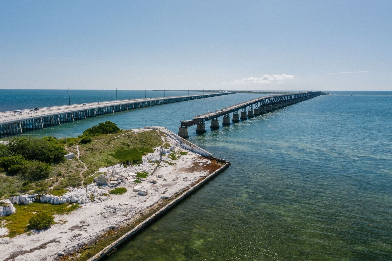
The bridge also makes weather feel immediate. A calm morning in Marathon can give way to stronger crosswinds, spray, glare, and a sharper sense of exposure halfway across the span. The surrounding waters are part of a larger coastal system that has experienced storm impacts and changing water conditions. Research on Hurricane Irma found that seagrass effects varied by location, with exposed areas more vulnerable to direct wind and wave damage and estuarine areas more sensitive to runoff and prolonged water-quality changes. That is a useful reminder that the Middle Keys are not just a scenic midpoint, but a meeting place between different marine environments.
The Lower Keys Wilderness Down to Stock Island
Southwest of the bridge, the landscape becomes quieter and more ecologically pronounced. Big Pine Key and nearby No Name Key, around MM 33 to MM 30, are associated with pine rocklands, mangrove wetlands, low-density residential areas, and protected wildlife habitat. The endangered Key deer is the signature local concern. Reduced speed zones are not decorative warnings; they are designed to reduce collisions in an environment where deer may cross unexpectedly, especially around dawn, dusk, and nighttime.
- Drive below the posted limit in Key deer areas and expect animals near the shoulder.
- Never feed wildlife, stop in travel lanes, or pull onto fragile shoulders for photographs.
- Use marked turnouts and public parking areas rather than blocking narrow residential roads.
- Check weather and road conditions before committing to long drives during tropical weather or heavy rain.
Beyond Big Pine, the highway threads through Cudjoe Key, Sugarloaf Key, and Boca Chica before reaching Stock Island around MM 5 to MM 4. These communities reveal the Lower Keys as a series of distinct residential, military, ecological, and maritime landscapes rather than a single resort strip. Cudjoe Key was directly affected by Hurricane Irma in 2017, a storm that demonstrated how unevenly a linear island chain can experience wind, surge, flooding, and communication failures. The main road system showed resilience, but utilities and communications remained vulnerable, which is why weather awareness matters even when the highway itself appears open.
Peak visitor periods can turn the narrow highway into a patience test. Leave more time than the map suggests, avoid unsafe passing, maintain generous following distance, and expect bicycles, pedestrians, turning vehicles, trailers, and sudden wildlife movement. When a single lane is temporarily controlled by construction or an incident, obey flaggers and electronic signs rather than attempting shortcuts through residential streets. For second-home buyers, the same advice applies to everyday logistics: measure a property”s convenience by its actual mile-marker position, bridge access, emergency routes, and travel time, not just by the community name in a listing.
Navigating the Keys with the Confidence of a Local
The simplest way to read the Florida Keys is to combine three clues: the mile marker, the water side, and the community cluster. “MM 82, Oceanside” immediately suggests an Islamorada-area location with Atlantic-facing orientation. “MM 31, Bayside” points toward the Big Pine and Lower Keys environment, where mangroves, shallow backcountry waters, and wildlife concerns become more prominent. This method is faster and more locally meaningful than relying on a string of GPS coordinates.
The Overseas Highway is not a monotonous two-lane road stretched over water. It is an interconnected sequence of coral-reef access points, mangrove wetlands, pine rocklands, marinas, working docks, historic bridges, residential coves, and distinct island cultures. Slow down, watch the mile markers, identify Bayside and Oceanside orientation, and plan around weather, traffic, wildlife, and bridge conditions. Once the numbering system becomes familiar, the journey feels less like crossing a distant chain of islands and more like moving confidently through a series of readable neighborhoods.