Riding the Rails Over Open Water: How Henry Flagler Built the Modern Florida Keys
Driving Across an Ocean Built on Flagler’s Dream
Few American road trips deliver such a cinematic sense of place as the Overseas Highway. US-1 runs south from the Florida mainland through the Keys, with turquoise water flashing between mangroves, bridges, fishing channels, and low island horizons. The drive feels effortless today, but every mile carries the imprint of a far more difficult undertaking: Henry Flagler’s Overseas Railroad.
In 1905, Flagler committed to extending the Florida East Coast Railway from the mainland to Key West, a distance that demanded bridges across open water and exposed the limits of early twentieth-century engineering. For travelers planning an island getaway around historic sites, understanding Flagler’s railroad legacy adds meaning to familiar overlooks, bridge walks, and roadside stops.
The railroad is often remembered as a spectacular failure because the 1935 Labor Day hurricane destroyed much of it. That interpretation misses its greater legacy. The surviving viaducts, piers, right-of-way, and bridge foundations became the physical framework for the modern Overseas Highway. Today, visitors can walk portions of the old route, explore the former construction camp at Pigeon Key, and see how a railroad built for commerce ultimately created the road trip that defines the Florida Keys.
Building the Eighth Wonder of the World Over Treacherous Channels
Flagler’s decision was driven by more than a love of grand projects. Key West possessed a deep-water harbor, a strategic position near the Caribbean, and an established maritime economy. Flagler believed the island could benefit from growing trade with Cuba, Latin America, and the future Panama Canal. A direct rail connection promised to move passengers, freight, and mail between the mainland and the port more efficiently than a combination of rail and ship travel.
Construction began in 1905 under conditions that made ordinary railway work seem relatively simple. Crews operated across isolated islands and shallow channels where tides complicated surveying and material delivery. Heat, insects, disease, limited fresh water, hurricanes, and dangerous industrial work took a steady toll. Engineers had to design long concrete viaducts, steel spans, causeways, and trestles that could withstand saltwater exposure and powerful currents while remaining stable on uncertain foundations.
The project consumed enormous sums and required years of persistence. Roughly 200 workers died during construction according to historical accounts, while skeptics called the undertaking “Flagler’s Folly.” Yet the line reached Key West in January 1912. The first train carried Flagler himself, marking the completion of a railway that contemporary observers treated as an engineering wonder. Its importance was not simply symbolic. It connected every major island in the chain to the mainland and changed the geography of travel, trade, and settlement.
- Construction period: Work continued from 1905 until the railroad reached Key West in 1912.
- Primary challenge: Engineers had to carry rail infrastructure across open channels exposed to tides, storms, and corrosion.
- Human cost: Historical accounts attribute roughly 200 worker deaths to the difficult construction conditions.
- Long-term result: The rail corridor later supplied the right-of-way and structural foundation for the Overseas Highway.
For modern visitors, the important point is that Flagler’s achievement was not erased when trains stopped running. Concrete piers and bridge alignments continued to shape transportation across the Keys. The same bold decision that once brought rail passengers to Key West eventually made the islands accessible to motorists, cyclists, families, and independent travelers.
The 1935 Labor Day Tempest and the Transition to Highway Asphalt
The Overseas Railroad remained vulnerable to the environment it had crossed. On September 2, 1935, a Category 5 hurricane struck the Upper Keys with extraordinary force. A barometric pressure reading of 892 millibars established a record at the time, and researchers have estimated maximum sustained winds near 185 miles per hour. The storm surge swept across low-lying islands, destroyed railroad infrastructure, and overwhelmed work camps.
Hundreds of people died in the Keys, including World War I veterans employed in Depression-era work programs. A relief train sent to evacuate veterans was delayed and then swept from the tracks by rising water, although everyone aboard the train survived. The wider disaster prompted political investigations and exposed the dangers of relying on limited storm forecasting and communication. The event is documented in detail by NOAA’s account of the Labor Day hurricane.
The Florida East Coast Railway was already financially weakened, and repairing the destroyed line no longer made economic sense. The company sold the remaining bridges and right-of-way to Monroe County and the state. That decision transformed a ruined railroad corridor into a transportation asset. Existing county road initiatives had already begun before the hurricane, including bond-funded improvements during the 1910s and 1920s. Early roads, ferries, and bridge projects were gradually being assembled into a continuous route.
After the storm, contractors adapted usable railroad bridges and built road connections over sections of the former corridor. The Bahia Honda crossing presented particular technical difficulties, but the work progressed with public funding and Depression-era employment programs. The Overseas Highway opened to traffic in 1938, creating a dependable vehicle connection between the mainland and Key West. The modern road therefore did not emerge from the hurricane alone. It was the result of years of local road building, county bond initiatives, federal support, and the practical reuse of Flagler’s infrastructure.
Comparing Flagler’s Rail Route with the Modern Overseas Highway
The 1912 railroad and today’s Overseas Highway occupy broadly the same island corridor, but they served very different travelers. Railway passengers crossed the water in enclosed cars pulled by locomotives, while modern drivers move at their own pace between marinas, state parks, neighborhoods, restaurants, and waterfront viewpoints. The early route prioritized freight and passenger rail service to Key West; the contemporary route supports private vehicles, commercial traffic, tour buses, cyclists, and emergency access across a busy island chain.
| Feature | Overseas Railroad | Modern Overseas Highway |
|---|---|---|
| Opening era | Reached Key West in January 1912 | Opened to highway traffic in 1938 |
| Primary transport | Locomotives and passenger or freight trains | Cars, buses, delivery vehicles, and bicycles |
| Route foundation | Concrete viaducts, steel spans, trestles, and causeways | Former railroad right-of-way plus later road connections and replacement bridges |
| Bridge legacy | Built for rail loads and exposed marine conditions | Older spans were adapted temporarily or continued in other uses as newer bridges appeared |
| Travel experience | Scheduled, enclosed, and commercially focused | Flexible, scenic, and designed for island-to-island road travel |
Several old railroad structures carried motor traffic for decades. Sections associated with Long Key and Bahia Honda were adapted for highway use until newer bridges and replacement crossings were completed during later modernization, particularly in the 1970s and 1980s. The result is a layered transportation landscape: a driver may cross a modern bridge while an older concrete span runs nearby, carrying pedestrians, cyclists, fishing activity, or historic interpretation.
Where to Walk and Bike Flagler’s Surviving Iron and Concrete Today
Pigeon Key is one of the most rewarding places to connect Flagler’s engineering story with the living Keys environment. Located beneath the Old Seven Mile Bridge, the small island served as a construction camp for railroad workers. The site now offers historic tours, museum exhibits, educational programming, picnicking, wildlife viewing, and marine activities. Visitors should check current access arrangements and tour availability before setting out, since transportation and weather conditions can affect the day’s experience.
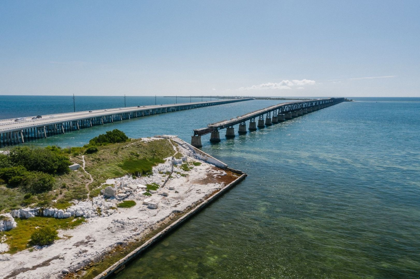
The restored pedestrian section of the Old Seven Mile Bridge extends about 2.2 miles toward Pigeon Key. Walking or cycling this span provides a close look at the scale of the original project, with open water on both sides and broad views across the Middle Keys. The exposed setting is beautiful but demanding. There is little shade, the sun reflects intensely from the water, and wind can make the return journey feel longer than expected.
Bahia Honda State Park offers another strong vantage point. The park’s Bahia Honda Bridge Trail leads up onto the original railroad alignment, celebrated for its distinctive steel Pratt and Parker through-truss spans, and provides panoramic views over the Atlantic Ocean and Gulf of Mexico. The structure is especially valuable for travelers who want to see how the railroad occupied the landscape rather than simply read about it. Conditions can be uneven, and some portions may be restricted or affected by preservation work, so follow current park guidance.
Several preserved railroad features and associated sites are officially recognized in historic documentation, including records in the National Register of Historic Places. That designation helps explain why these places deserve careful treatment. Old concrete, iron, and timber are not disposable scenery; they are irreplaceable evidence of how the Keys were connected.
- Start early: Morning is usually the most comfortable time for bridge walks, with lower heat and stronger chances of avoiding the harshest midday sun.
- Plan parking carefully: Parking areas at popular parks and bridge access points can fill during winter, weekends, and holiday periods. Arrive with a backup stop in mind rather than stopping on narrow shoulders.
- Check transportation details: Motorized visitor access to Pigeon Key is provided via the open-air Pigeon Key Express tram across the restored 2.2-mile span of the Old Seven Mile Bridge, though guests may also walk or bicycle across. Confirm departure schedules and tour bookings directly with the Pigeon Key visitor center before arriving.
- Bring practical gear: Carry water, sun protection, a hat, sturdy footwear, and insect repellent. A light layer can also help on windy bridge sections.
- Respect the structure: Stay on permitted paths, obey closures, avoid climbing historic elements, and leave marine life and shoreline habitats undisturbed.
For travelers seeking more than beach time, these stops create a useful half-day or full-day history circuit. Pairing a bridge walk with a state park visit and a Pigeon Key tour keeps the experience varied, combining engineering, wildlife, water views, and the practical realities of traveling across exposed islands.
Set Out Along the Trail Flagler Blazed Over the Sea
Every modern mile of the Keys road trip follows a route shaped by a century-old act of ambition. The asphalt highway may feel relaxed, but its underlying geography was established by crews who surveyed shifting channels, poured concrete in difficult conditions, and built a railway across a chain of vulnerable islands. Flagler’s railroad did not survive intact, yet its corridor made the modern Keys possible.
Slow the drive occasionally. Pull into a permitted historic or park access point, step onto an old span, and feel the wind moving across the same open water that challenged the railroad builders. The Florida Keys are both a sun-soaked destination and a living museum of engineering courage, and the most memorable visit allows enough time for both sides of that identity.